Hà Giang Loop - Vietnam at it's best
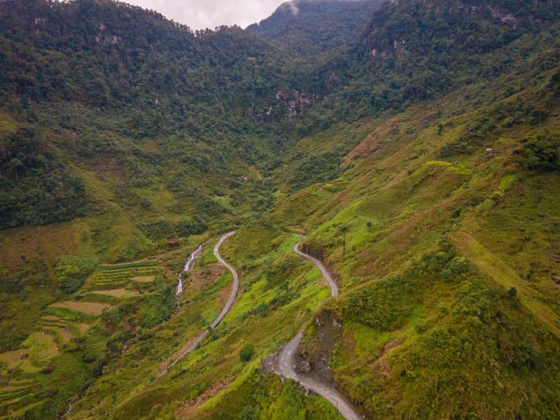
Driving through Vietnam's most breathtaking landscapes? The Hà Giang Loop is a multi-day trek across Vietnam's mountains in the northeast. biking through distinctive villages where numerous ethnic minorities live, being startled by unexpected sights every kilometer, and passing as near as 20 meters from the Chinese border. The route's numerous gorgeous mixes of curves will make scooter and motorcycle enthusiasts drool even more.
In my opinion, a must during your visit to Vietnam, but of course, it is handy to have some extra information. You can find out more about the route in this page, along with some useful advice!

Alone or on a tour?
The first, and possibly most important, question is: Should I drive myself or take a tour? The Hà Giang Loop is renowned for having difficult roads. Frankly, I believe that the internet description of the route is a bit exaggerated, but such titles frequently get more clicks. If you pay close attention to what is going on in front of you, you can drive it properly on your own.
You'll be riding on a semi-automatic scooter when going on your own (or with a tour). Semi-automatic scooters with four gears are the most popular mode of transportation in Vietnam. This is due to the fact that they are less expensive than automatic scooters, and using an automatic scooter also puts you at a disadvantage due to the altitude variations in the mountains. Another choice is a motorcycle, although renting one costs more.
To fully concentrate on the roadways, it is advised that you have some prior scooter expertise (but of course, occasionally look around when safe to enjoy the view a bit more).

Presenting the options
- Self-driving is the least expensive and most flexible way to choose your own path and make stops where a tour might not. You can drive at your own pace and independently of other drivers.
- Tour: great if you're looking to meet individuals while you drive in a group. usually involves spending the night in homestays. Further background information about the route, the villages, and the culture will also be provided. Yet, because they organize a lot for you, it is more expensive than self-driving.
- Easyrider: essentially identical to the tour. The main distinction is that you ride on the back of the easyrider's motorcycle or scooter rather than having to drive yourself.
My choice: self-driving (including costs)
I place a lot of value on having the freedom to go anywhere. I made the journey with a true motor enthusiast, so we occasionally had to crank up the pace. Although I didn't have that much experience personally (I'm a risk averrer), after 1.5 days of driving in Sapa, I felt comfortable operating a semi-automatic scooter.
The cost breakdown:
-
I spent 280,000 Vietnamese Dong per day renting a scooter (180,000 for the scooter and 100,000 for insurance). This costs about 11.20 euros. Also, I advise always acquiring insurance because accidents can occur at any time (more on that later).
-
Every day, fuel costs between €2.00 and €2.50.
-
Each of us spent about €6 for an overnight stay.
-
About €30 per day after adding in food and beverages. Perfect!
An Easyrider is an option if you still don't feel comfortable driving on your own.
The route
Over to the route! A 3- or 4-day route is most common, depending on how many KMs you would like to ride per day or so. I chose a 4-day route, but you can easily change it to suit your preferences based on how many kilometers you want to ride each day.
Starting point: Hà Giang
The route's starting is in the city of Hà Giang. It's not a big city by any means, so it makes the most sense to spend only one night there so you can plan everything out and start your trip well rested.
I slept at the Hong Hao Hostel and rented a scooter there as well. Highly recommended! You will meet people there who, like you, are also starting or who have just completed the loop. Ideal for exchanging some last-minute tips.

Day 1. Hà Giang – Yên Minh (112 KM)
It's a good idea to pay attention to the time depending on what time of year you take the trip. The sun set at 5:00 PM as I made the journey in December. Preferably, you should leave early to allow for stops along the way and avoid riding in the dark (which I would absolutely not recommend).
The first half is still rather simple, but you'll note that the roads start to get steeper as you approach the first settlement. The following are some of the day's highlights:
- Bac Sum Pass
- Núi dôi Mountains
- Sky Gate
- Lung Khuy Cave
- Hmong Village.
I also enjoyed driving through the villages themselves, there were a lot of decorations on the streets!


You reach Yên Minh after a 112 kilometer journey. There are many hotels and homestay options available here. The homestays are the most enjoyable because you can eat dinner with the family and other visitors (usually accompanied by happy water that goes hand in hand with a lot of Vietnamese cheers).
Happy water is fairly strong, so limit how much you consume to ensure that you're fit for day 2.

Happy water and a family dinner, some advantages of a Homestay!
Day 2. Yên Minh – Dong Van (88 KM)
You will still have a full day ahead of you despite taking a slightly shorter route than day 1. It's probably not a bad idea to stop more frequently to take in the scenery since the sights get even more stunning as the path continues.
Lūng Cú Flagpoint
The 59-kilometer journey to Lung Cu Flagpoint, Vietnam's farthest northern point, marks the start of the day. You will become aware of how far north you have traveled, especially in the last kilometers, when you reach a location only 20 meters from the Chinese border. Once you arrive at the Flagpoint, you will pay 40,000 Vietnamese Dong (€1.60) to climb the stairs up. 39 kilometers separate the Flagpoint from Dong Van, where you will ride a portion of the same route you used to get there.
You have the option to ride a few more miles in the direction of Phó Báng, home to the Hong & Moa ethnic groups, on your journey to Lung Cu.


Day 3. Dong Van – Du Già (90KM)
The road was excellent the first two days, but be prepared for roadwork on day three. The 182/176 from Mèo Vac to Du Già was closed due to roadwork when I traveled the route (in December 2022). An hour or so of unpleasant riding is to be expected. Riding your scooter over a lot of rocks and mud is not fun. Here, a motorcycle with improved suspension will be helpful. Yet, it's only a little portion, and the sights you see after that make the whole thing worthwhile.
Ma Pi Leng Pass
The first section of the route (Dong Van to Mêo Vac) is free of obstacles and takes you across the Ma Pi Leng Pass via a beautiful natural area. In my opinion, the section of the trip is the most beautiful. This is also the location where the popular (Instagramable) rock can be found (SkyWalk Viewpoint).
You must park the scooter here and then walk a short two kilometers upward. If you always go up, you'll understand why you can't ride your scooter up as a tourist: a brief distance along the ground.

You'll pass through a few towns en route to Du Già, where, with any luck, you might locate the neighborhood market. It's fun to be in the midst of the action. The fact that these minority groups are very different from the typical Vietnamese is what sticks out in this situation. There is a noticeable contrast in their appearance due to the quantity of color in their apparel.


Day 4. Du Già – Hà Giang (67 KM)
It's already the last day of the trip, and the poor roads are back in full force. A significant portion of the route's beginning is marked by roads with lots of potholes, riding over rocks, or through mud. Precaution is necessary!
You will see that you are gradually approaching the route's end in the last section. The route's beginning still has some lovely views, but after that, it loses some of its impact. You pay less attention to what is going on around you, especially when you have to concentrate more on the road.

Lastly, some driving advice!
Be careful with gravel!
For narrow scooter tires, gravel is especially difficult. You will slide into the asphalt and quickly become a passenger if your front wheel begins to skid. I had to learn this the hard way after sliding while turning downhill on day 1. I attempted to brake after going too fast through the corner, but the front wheel slid on the gravel. Fortunately, there wasn't much damage, although knee, elbow, and hand protection is strongly advised.
Refueling
anytime you have a chance, refuel. The fuel gauge is not always accurate due to how frequently you drive uphill and downhill. You feel more secure if you don't need to constantly check the gasoline gauge. About every settlement you pass through has a petrol station; there are several of them along the route. The scooters are quite economical and use about 1L for 30KM in the mountains.
Driving license
- The police only needed a Dutch scooter license (AM) from me to keep going. On the way, I passed through two checkpoints (day 1 in the first village and on day 3 just past Dong Van). I was able to continue driving after the first checkpoint required no documentation, but at the second, I was required to produce my driver's license.
- For my own safety, I obtained an international driver's license, but as was already said, the Dutch license was equally acceptable. It's still unclear, particularly in terms of insurance. Driving is therefore entirely at your own risk.
Driving
- While approaching hairpin twists and blind corners, honk loudly enough to alert oncoming traffic of your impending presence.
- Because the roads aren't particularly wide, you might need to move to the side to avoid hitting a truck.
Wishing you a lot of driving pleasure!
Next up: Cat Ba, Sapa or Hanoi?
- Cat Ba: 12 hours
- Sapa: 7.5 hours
- Hanoi: 6 hours


Create Your Own Website With JouwWeb